

Continue Reading
 There are places that announce themselves.
The Sundarbans does not.
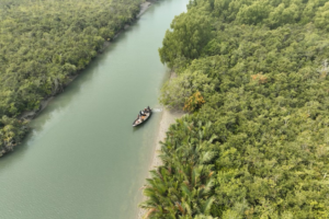
It appears slowly, almost quietly, as the water narrows and the banks begin to change. The familiar landscape gives way to mangrove trees, winding creeks and stretches of mud shaped by every passing tide. There are no grand gates marking its entrance. No road leads you into its heart. You enter by water, and the forest gradually takes over.
For many people, the Sundarbans begins and ends with the Royal Bengal Tiger.
And understandably so.
The tiger has become the great symbol of this forest—the animal that captures imagination, commands respect and reminds us that the Sundarbans still belongs, in many ways, to the wild.
But there is a much larger story here.
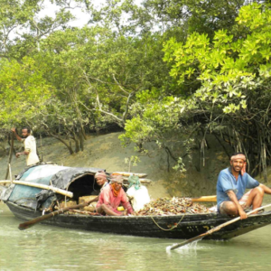
It is a story of tides and rivers. Of fishermen who read the water almost instinctively. Of mouals who enter the forest in search of wild honey. Of bawalis who venture into the mangroves for forest resources. Of crab and prawn collectors. Of boatmen who know the turns of waterways that may look almost identical to an outsider.
It is a story of people who have learned to live beside one of the most demanding environments on earth.
A Forest Made of Water
The Sundarbans is not simply a forest with rivers running through it.
The water is part of the forest itself.
The tides enter and retreat every day, carrying salt, silt and life deep into the mangrove channels. Banks disappear and return. Creeks change. Islands are reshaped. Places that seem permanent from one season may look remarkably different in another.
To travel through the Sundarbans is therefore to understand that the landscape is never entirely still.
Even when the surface of the water appears calm, something is moving beneath it.
The tide is coming.
Or going.
And the forest is responding.
The People Who Know the Forest
Long before the Sundarbans became a destination for visitors, it was a place of work and survival.
Generations of people have developed an intimate knowledge of its waterways and forests. They know where the channels become shallow, where the tide runs strongly, when the water is safe to cross and where a particular season may bring opportunity—or danger.
Their knowledge is rarely written in books.
It is learned through experience.
A fisherman may read the water differently from a tourist. A honey collector sees a forest differently from a photographer. A boatman knows a creek not merely by its name, but by its current, its depth and the way it behaves with the tide.
These are the people who form part of the living story of the Sundarbans.
Beyond the Tiger
There is a temptation, when telling the story of the Sundarbans, to focus only on what is dramatic.
The tiger.
The crocodile.
The great rivers.
The storms.
But much of the character of this forest lies in quieter things.
A kingfisher appearing briefly above a creek.
The sound of oars against still water.
A fishing boat disappearing around a bend.
The smell of mud exposed by a falling tide.
A line of mangroves reflected in the water at dawn.
The distant call of a bird from somewhere beyond the trees.
These moments may never appear in a wildlife documentary, but they are part of what makes the Sundarbans what it is.
The forest is not simply a place to search for animals.
It is a living landscape to observe.
A Changing Sundarbans
The Sundarbans is also a changing place.
Its people have always understood change through the movement of water, but today the pressures on the forest are increasingly difficult to ignore.
Storms, rising salinity, erosion, changing waterways and the broader effects of a warming climate are influencing both the natural environment and the communities that depend upon it.
Some changes happen dramatically.
Others are almost impossible to notice from one visit to the next.
But over years, the differences become part of the story.
An island changes.
A channel becomes narrower.
A familiar bank moves.
A community adapts.
The Sundarbans has always changed with the tide. The question is how quickly, and how deeply, those changes are now taking place.
Why We Travel Here
At Blue Sail Travelers, we do not see the Sundarbans simply as somewhere to visit.
We see it as somewhere to spend time.
To travel through it is to accept that the forest sets the rhythm. The tide determines the route. The weather changes the mood. A quiet morning may become the most memorable part of a journey.
Our boats give us a way to enter that world slowly.
There is time to stop.
Time to watch.
Time to listen.
And sometimes, most importantly, time to do nothing at all.
Because not every journey needs to be measured by how many places were visited.
Sometimes the better measure is what you noticed along the way.
The Forest Keeps Its Own Time
The Sundarbans does not need to be hurried.
It has been shaped by water for generations, and it continues to change according to rhythms much older than our own.
Perhaps that is one of the reasons we keep returning.
Not because everything remains the same, but because it does not.
Every tide brings something different.
Every season changes the forest.
Every journey leaves behind a different memory.
And beyond the tiger—beyond the photographs, the famous names and the familiar stories—there remains a vast, living world of water, trees, wildlife and people.
That is the Sundarbans we want to explore.
Not simply the forest you come to see.
But the forest you come to understand.
Continue Reading
 The Sundarbans is frequently approached as a significant mangrove ecosystem and as habitat for a distinctive assemblage of wildlife, most notably the Royal Bengal Tiger. Such representations, while important, can obscure another fundamental dimension of the landscape: the long-standing relationship between human communities and the forest’s aquatic and terrestrial environments.
For communities living adjacent to the Sundarbans, the forest is not an isolated wilderness separated from human society. It forms part of a broader social-ecological system in which rivers, tidal channels, mangrove forests, fisheries, forest products and settlements are interconnected. Livelihoods have consequently developed in response to the particular environmental conditions of the region, including tidal fluctuation, seasonal variability, salinity, sediment movement and periodic extreme weather.
Understanding the Sundarbans therefore requires more than an examination of its biodiversity. It also requires attention to the people whose economic activities, cultural practices and accumulated environmental knowledge have developed in close association with the forest.
A Tidal Landscape
The physical character of the Sundarbans is fundamentally influenced by tidal processes. The interaction of freshwater flows, marine influence, sediment deposition and erosion produces a landscape in which waterways and landforms are continually subject to change.
For communities dependent upon the rivers and channels, this dynamism has practical consequences. Navigation, fishing and access to forest resources require an understanding of water depth, currents, seasonal conditions and tidal movement. Such knowledge is often experiential rather than formally documented and may be transmitted through families and occupational communities.
This form of environmental knowledge is significant because conventional maps provide only a static representation of a landscape that is, in reality, continually changing. People who regularly work on the waterways develop a more immediate understanding of these changes through repeated interaction with their surroundings.
The relationship is therefore reciprocal in a practical sense: the environment determines many of the conditions under which livelihoods can be pursued, while human communities develop strategies for adapting to those conditions.
Fisheries and River-Based Livelihoods
Fishing constitutes an important livelihood activity for communities associated with the Sundarbans and its surrounding waterways. The availability and distribution of aquatic resources are influenced by ecological conditions, seasonal cycles and hydrological processes, requiring fishermen to adjust their activities according to changing circumstances.
Fishing in such an environment involves more than the possession of equipment or access to a particular location. Knowledge of waterways, weather conditions, tides and seasonal patterns can significantly influence the efficiency and safety of fishing activities.
The river consequently functions simultaneously as an ecological system and an economic space. Its resources contribute to household income and food security, while its physical characteristics impose constraints upon those who depend upon it.
This dependence also creates vulnerability. Changes in fish populations, restrictions on access, environmental degradation, extreme weather events and broader socioeconomic pressures can all affect fishing households.
Honey Collection and the Moual Tradition
Honey collection represents one of the most distinctive traditional uses of the Sundarbans. The mouals enter designated forest areas during the honey-gathering season to collect honey from wild bee colonies associated with the flowering cycles of mangrove vegetation.
The activity illustrates the importance of seasonal ecological knowledge within forest-dependent livelihoods. Honey collection cannot be separated from an understanding of flowering periods, forest conditions, bee behaviour and the practical characteristics of particular forest areas.
The knowledge associated with this occupation has traditionally been transmitted through participation and experience. It therefore represents more than an economic technique; it forms part of a broader body of locally developed environmental knowledge.
At the same time, honey collection demonstrates the limits of describing forest-dependent livelihoods solely in economic terms. Such activities exist within a regulatory and ecological framework in which access to forest resources must be balanced against the conservation requirements of a highly sensitive ecosystem.
Forest Resource Collection and the Bawali
The bawali tradition provides another example of the historical relationship between human communities and the Sundarbans. Traditionally associated with the collection of forest resources, bawalis have developed occupational knowledge concerning movement through the forest, seasonal conditions and the identification and use of available resources.
The importance of this knowledge extends beyond the immediate activity of resource collection. Navigating a complex mangrove environment requires familiarity with waterways, vegetation, tidal conditions and local geography. Much of this knowledge is acquired incrementally through experience and social transmission.
Such practices demonstrate that indigenous and locally developed environmental knowledge can constitute an important component of human adaptation to difficult ecological environments.
However, these traditions must also be understood within the changing institutional framework governing access to the Sundarbans. Conservation policies, restrictions on resource extraction and changing economic conditions can significantly influence whether traditional occupations remain viable.
Communities and Conservation
The relationship between human livelihoods and conservation is sometimes presented as a straightforward opposition between socioeconomic necessity and environmental protection. The reality is considerably more complex.
The communities surrounding the Sundarbans have historical connections with the forest, while the forest itself provides resources and ecological services upon which surrounding populations may depend. At the same time, unrestricted extraction can place pressure upon ecological systems that are already subject to significant environmental and climatic stresses.
Effective conservation therefore involves more than protecting forests from human activity. It also requires consideration of the socioeconomic circumstances of the populations living around protected areas.
This is particularly important because restrictions on forest access can have unequal consequences. A household with alternative sources of income may be better positioned to adapt to restrictions than one whose livelihood depends directly upon fishing or forest resources.
The relationship between conservation and local livelihoods must consequently be examined through both ecological and socioeconomic perspectives.
Environmental Change and Vulnerability
The Sundarbans is situated within a region exposed to multiple environmental pressures. Salinity, erosion, sedimentation, cyclonic storms and changing hydrological conditions can affect both ecological processes and human settlements.
For communities living near the forest, environmental change is therefore experienced through tangible socioeconomic effects. Changes in water quality or salinity can influence agricultural production and fisheries; erosion can alter settlement patterns and land availability; and severe cyclones can damage homes, boats, infrastructure and sources of income.
Climate change adds another dimension to these existing pressures. Its significance should not be understood solely through individual environmental indicators, because ecological change and social vulnerability interact. The capacity of a household or community to respond depends upon factors including income, access to alternative livelihoods, infrastructure, education, institutional support and mobility.
The Sundarbans consequently provides an important example of a broader principle in environmental studies: ecological vulnerability and social vulnerability are frequently interconnected.
The Unseen Household Economy
The economic relationship between communities and the Sundarbans extends beyond the individuals who physically enter the forest or work on the waterways.
Forest-dependent livelihoods are embedded within households. When a fisherman, honey collector or forest worker spends extended periods away from home, other members of the household undertake responsibilities that sustain family life during that absence.
Women, in particular, may perform substantial unpaid domestic and care work while simultaneously participating in income-generating activities. Such contributions can be overlooked when livelihood studies focus primarily on the person formally identified with an occupation.
A complete understanding of Sundarbans communities therefore requires attention to the household as an economic and social unit rather than examining occupational activity in isolation.
Intergenerational Knowledge
One of the less visible resources associated with the communities of the Sundarbans is accumulated environmental knowledge.
Knowledge of tides, channels, seasons, weather patterns, forest resources and local geography can represent decades or even generations of observation. It is frequently communicated informally through families, apprenticeships and participation in occupational activities.
Yet the continuity of this knowledge cannot be assumed.
Changes in livelihood opportunities, education, migration, conservation regulations and economic aspirations may reduce the number of younger people entering traditional occupations. In such circumstances, knowledge that was once essential to everyday economic activity may gradually become less widely transmitted.
This raises an important question for both social research and conservation policy: how can valuable local knowledge be documented and understood without treating communities merely as repositories of traditional information?
The answer requires recognising local people not simply as users of the forest, but as social actors whose knowledge has developed through sustained interaction with a changing ecosystem.
Beyond the Conventional Narrative
The Sundarbans is often represented through two dominant narratives: the wilderness narrative, centred on biodiversity and iconic wildlife, and the livelihood narrative, centred on communities that depend upon forest resources.
Neither is sufficient on its own.
The forest is simultaneously an ecological system, a regulated conservation landscape, an economic resource, a cultural environment and a lived social space. These dimensions overlap continuously.
The people who live beside the Sundarbans are neither merely beneficiaries of its resources nor inherently threats to its ecological integrity. Their relationship with the forest is shaped by necessity, opportunity, regulation, knowledge, history and changing environmental conditions.
Understanding this complexity is essential if discussions about the future of the Sundarbans are to move beyond simplified distinctions between nature and society.
Conclusion
The people of the Sundarbans live within a landscape defined by movement. Tides alter waterways, rivers reshape land, seasons influence livelihoods and extreme weather periodically transforms the conditions of everyday life.
Over generations, communities have developed occupational practices and environmental knowledge suited to these circumstances. Fishing, honey collection and forest-resource gathering represent not only economic activities but also forms of adaptation to a distinctive ecological environment.
That relationship, however, is not static. Environmental change, conservation policy, demographic movement and economic transformation are reshaping the circumstances under which traditional livelihoods can continue.
To understand the Sundarbans fully, therefore, requires looking beyond its most recognisable wildlife and beyond the idea of the forest as an untouched wilderness. Its history is also a human history: one in which communities have learned to negotiate the opportunities and constraints of a tidal ecosystem whose boundaries are continually being rewritten.
The tide is not merely a physical process in the Sundarbans. It is one of the forces around which human life has been organised for generations.
Continue Reading
On a map, an island appears certain. It has a name, a position and a boundary. In the Sundarbans, however, certainty is temporary.
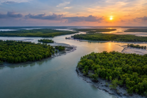
The apparent solidity of the landscape conceals a continuous process of formation and disappearance. Rivers carry sediment towards the Bay of Bengal, tides redistribute it across channels and mudflats, and currents gradually erode some banks while building others. Mangrove vegetation then colonises newly deposited sediments, stabilising portions of the developing land while simultaneously influencing the movement of water around it.
The result is a landscape that is never completely finished.
An island in the Sundarbans may remain recognisable for generations, yet its shoreline can advance, retreat or change direction over comparatively short periods. Channels may narrow or widen, mudflats may emerge where water once flowed, and sections of land can gradually disappear into the same tidal system that created them.
The geography of the Sundarbans is therefore better understood as a process than as a collection of fixed places.
A Delta Still Being Made
The Sundarbans occupies the seaward part of the Ganges–Brahmaputra–Meghna delta, one of the world’s largest deltaic systems. The immense quantity of sediment transported downstream by these rivers provides the fundamental material from which much of the delta has been constructed.
Sediment does not, however, simply arrive at the coast and remain where it is deposited.
The interaction of river discharge, tides, waves and currents continually redistributes material. Fine sediments can settle in relatively sheltered areas, while stronger flows can transport or remove them. Over time, these processes produce a constantly changing arrangement of channels, mudflats, sandier deposits and vegetated islands.
This helps explain why the Sundarbans cannot be regarded as a conventional landmass surrounded by stable waterways. It is part of an active delta in which land and water are continually exchanging places.
Erosion and Accretion
Two processes are particularly important in understanding this changing geography: erosion and accretion.
Erosion removes sediment from an existing bank or landform. Tidal currents, river flow, waves and storms can all contribute to this process. Where erosion exceeds the deposition of new material, the shoreline retreats and land is progressively lost.
Accretion is the opposite process. Sediment accumulates in an area, gradually raising or extending the land surface.
These processes rarely occur independently. A section of a riverbank may be eroding while sediment is simultaneously being deposited a short distance away. Material removed from one location can therefore contribute, directly or indirectly, to the formation of another.
The disappearance of land in one place may consequently be part of the creation of land somewhere else.
This is one of the fundamental characteristics of a deltaic environment.
The Role of the Tide
The tide gives the Sundarbans much of its distinctive character.
Twice each day, tidal water moves through an extensive network of rivers, creeks and channels, transporting sediment and influencing the distribution of water across the landscape. The relative strength and direction of these flows vary according to location, tidal conditions, freshwater discharge and seasonal factors.
The effect is not merely to raise and lower the water level. Tidal movement participates in the redistribution of sediment and therefore contributes to the long-term evolution of the landscape.
A channel that appears insignificant during one stage of the tide may become a substantial flow path at another. Conversely, areas that seem permanently submerged may become exposed as mudflats when water levels fall.
For this reason, the geography of the Sundarbans can look different even within the course of a single day.
When Mangroves Begin to Build Land
The relationship between vegetation and sediment is particularly important.
Newly deposited mud and sediment may initially form exposed flats. Under suitable conditions, mangrove vegetation can establish itself on these developing surfaces. As plants become established, their roots and above-ground structures influence the movement of water and the retention of sediment.
Mangroves therefore do more than occupy land that has already formed. They can participate in the process by which newly deposited material becomes increasingly stabilised.
This creates an important interaction between geomorphology and ecology.
The physical environment influences where vegetation can establish, while vegetation can subsequently modify the physical environment around it.
In this sense, a mangrove island is neither purely geological nor purely biological. Its development is the product of continuing interaction between sediment, water and living organisms.
Islands Are Not Equal
Not every island within the Sundarbans develops in the same way.
Differences in elevation, sediment composition, exposure to tidal currents, freshwater influence and vegetation can produce significant variations between neighbouring landforms. Some areas may accumulate sediment relatively quickly, while others experience persistent erosion.
The shape of an island can also change without the island disappearing altogether. A shoreline may retreat along one side while extending on another, producing gradual changes in area and configuration.
Consequently, asking whether an island is “growing” or “shrinking” can sometimes oversimplify what is actually happening.
Different parts of the same landform may be undergoing different processes simultaneously.
The Human Dimension
For communities living around the Sundarbans, changing geography is not simply a subject for geomorphologists.
Changes in river channels and shorelines can influence navigation, fishing, access to resources and the location of settlements and infrastructure. Where erosion affects inhabited areas, the consequences may include the loss of agricultural land, homes or other assets. Where new land emerges, its ecological and legal status may develop over time according to different processes.
The instability of the physical landscape therefore introduces an element of uncertainty into human geography.
A boundary that appears permanent on a map may not correspond precisely to the physical reality several years later. A familiar route may become difficult to navigate, while another channel gradually becomes more important.
People living within and around the delta must therefore adapt not only to seasonal change but also to longer-term geographical transformation.
Storms and Sudden Change
Most landscape change occurs gradually, but the Sundarbans is also exposed to events capable of producing rapid transformation.
Tropical cyclones and associated storm surges can cause extensive erosion, redistribute sediment and inundate large areas. A single severe event may alter shorelines that would otherwise have changed only incrementally over many years.
Storms can therefore interrupt the slower rhythm of delta formation.
Their effects are not limited to the immediate physical landscape. Damage to vegetation, settlements, embankments, boats and infrastructure can influence the ability of communities to recover and adapt.
The long-term geography of the Sundarbans is consequently shaped by both persistent processes and occasional extreme events.
A Changing Coastline
The future geography of the Sundarbans is increasingly discussed in the context of climate change and sea-level rise.
These issues cannot be reduced to a simple prediction that the sea will advance and the forest will disappear. The response of a delta depends upon several interacting factors, including sediment supply, land subsidence, tidal dynamics, vegetation, human intervention and the rate of sea-level change.
In some locations, sediment accumulation may partially offset rising water levels. In others, erosion or subsidence may produce a different outcome.
The important point is that the future of the Sundarbans will be determined by the interaction of multiple processes rather than by a single environmental variable.
This makes the region both scientifically significant and exceptionally complex.
A Geography Without Permanence
The most striking characteristic of the Sundarbans may therefore be its lack of permanence.
The forest appears solid, yet its foundations are continually being modified. Rivers appear to define boundaries, yet those boundaries move. Islands carry names and histories, yet their physical forms are subject to erosion and deposition.
This does not mean that the Sundarbans is unstable in every sense. The broader ecosystem has demonstrated remarkable persistence over long periods. What changes is the configuration through which that ecosystem expresses itself.
Land becomes water.
Water becomes land.
A channel loses importance while another becomes dominant.
Vegetation establishes itself on new sediment and, in turn, changes the conditions around it.
The process continues.
The Map and the Landscape
There is an important distinction between a map of the Sundarbans and the Sundarbans itself.
A map provides a necessary representation of geographical space, but it inevitably freezes a landscape that is constantly changing. Coordinates, boundaries and names provide reference points for human understanding; they do not stop the physical processes occurring beneath them.
Perhaps this is why the Sundarbans can appear strangely unfamiliar even to someone who has visited before.
The forest has not necessarily moved dramatically.
The relationship between land and water has.
And in a landscape governed by tides, sediment and time, that distinction matters.
The islands of the Sundarbans are not monuments.
They are processes.
They are temporary expressions of a much larger interaction between river, sea, sediment and life—a geography still being written, one tide at a time.
Continue Reading
A mangrove forest appears, at first glance, to be an improbable place for trees to grow. Its roots occupy waterlogged sediment, its surroundings may be influenced by seawater, and the soil can contain concentrations of salt that would severely constrain most terrestrial plants.
Yet mangroves do not merely tolerate these conditions. They have evolved a suite of specialised physiological and structural adaptations that allow them to function within environments where salinity, tidal inundation and oxygen-poor soils occur together.
The Sundarbans provides one of the world’s most extensive examples of this ecological strategy. Its mangrove vegetation occupies a dynamic transition between freshwater-influenced rivers and the saline waters of the Bay of Bengal, producing gradients in which different species and forest communities experience markedly different environmental conditions.
The forest is therefore not simply a collection of trees growing beside the sea. It is a biological system adapted to an environment in which the fundamental requirements of plant life—freshwater, oxygen and stable ground—cannot be taken for granted.
The Problem with Salt
For most plants, salt presents a fundamental physiological problem.
Plants require water to maintain cellular function, transport nutrients and support photosynthesis. When the surrounding soil becomes highly saline, however, the concentration of dissolved salts outside the roots can make it more difficult for plants to take up water. At sufficiently high salinity, plants can experience what is broadly described as physiological drought: water may be present in the soil, but it becomes energetically difficult for the plant to extract it.
Salt ions can also accumulate within plant tissues and interfere with cellular processes.
Mangroves have evolved different strategies for managing both problems. Some species restrict the movement of salt into their tissues at the root level, while others tolerate or regulate absorbed ions and subsequently remove or isolate excess salt. These strategies are not identical across mangrove species, which is one reason different species perform differently along salinity gradients.
In the Sundarbans, this distinction is particularly significant because salinity varies considerably across the forest.
Keeping Salt Out
One of the most effective strategies is to prevent excessive salt from entering the plant in the first place.
Certain mangrove species possess highly selective root membranes that restrict the movement of salt ions into the plant’s vascular system. The root therefore functions not simply as a structure for anchorage and water absorption, but also as part of a sophisticated physiological filtering system.
This is an important distinction. Mangroves are not simply drinking seawater in the same manner that a terrestrial tree absorbs freshwater from ordinary soil. Their roots regulate what enters the plant, while the plant manages the resulting water and ion balance through a combination of physiological mechanisms.
This capacity for selective uptake allows some mangrove species to occupy environments that would impose severe water stress on ordinary plants.
When Salt Gets In
Not all mangroves rely primarily upon exclusion.
Some species allow salt to enter and subsequently regulate its concentration within the plant. Certain mangroves possess specialised salt glands associated with their leaves that can transport excess salt back to the surface, where it may accumulate as visible crystals.
Other species can compartmentalise unwanted ions within particular tissues or concentrate them in ageing leaves that are eventually shed.
These mechanisms illustrate an important principle of mangrove biology: there is no single “mangrove solution” to salinity.
Different species have evolved different combinations of exclusion, secretion, storage and tissue-level regulation. The result is a diverse group of plants occupying broadly similar environments through different physiological strategies.
The Problem Beneath the Surface
Salt is only one of the problems.
Mangrove soils are frequently saturated with water, which creates another major challenge for plants: a shortage of oxygen around the roots.
Most terrestrial soils contain air-filled spaces through which oxygen can move towards underground roots. In waterlogged sediment, these spaces become filled with water and the movement of oxygen is severely restricted.
A conventional root system is therefore poorly suited to prolonged waterlogging.
Mangroves have responded with some of the most distinctive root structures found in the plant kingdom.
Roots That Breathe
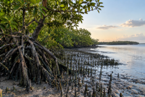
In several mangrove species, roots extend horizontally through the upper layers of sediment and produce specialised structures that reach above the soil surface.
These structures are known as pneumatophores.
They may appear as numerous small projections rising from the mud around a tree, but their function is considerably more important than their appearance suggests. Their surfaces contain specialised openings through which gases can be exchanged, allowing oxygen from the atmosphere to reach portions of the root system despite the oxygen-poor conditions below ground.
Other mangroves use different architectural solutions.
Some develop extensive prop or stilt roots that provide mechanical support in unstable sediment while also contributing to gas exchange. Others form knee roots or specialised horizontal root structures.
The diversity of these forms reflects the same underlying problem: the plant must remain anchored in unstable, waterlogged ground while still obtaining sufficient oxygen for its living tissues.
Trees Designed for Unstable Ground
The physical environment of the Sundarbans presents another challenge. Tidal currents continually interact with soft sediment, while erosion and deposition can modify the shape and elevation of the ground.
Mangrove root systems help trees remain anchored under these conditions.
Their extensive networks can spread laterally through sediment rather than relying exclusively upon a single deep root system. This provides mechanical stability while also increasing the interface between the plant and its difficult environment.
But the relationship works in the opposite direction as well.
Mangrove roots can influence sediment movement by slowing water and trapping suspended material. As sediment accumulates around vegetation, the physical structure of the developing surface can change.
The tree therefore becomes both a product of its environment and an agent capable of modifying that environment.
A Forest Arranged Along a Salinity Gradient
The Sundarbans should not be imagined as having one uniform level of salinity.
Freshwater influence, tidal exchange, seasonal rainfall, evaporation, sediment characteristics and geographical position all contribute to spatial differences in salinity. The result is a gradient rather than a simple division between “fresh” and “salt” water.
This gradient has ecological consequences.
Species differ in their tolerance of salinity, and increasing salinity can affect growth, forest structure, species composition and ecosystem functioning. Research in the Bangladesh Sundarbans has found that increasing salinity is associated with reductions in several measures of forest performance, while nutrient availability and other site characteristics can moderate some of these effects.
The forest is therefore structured not only by where water reaches the land, but by the chemical character of that water and soil.
Salt Does Not Make the Forest Invulnerable
It would be a mistake to interpret mangrove adaptations as evidence that salinity cannot harm them.
Adaptation has limits.
Mangroves have evolved to function within particular environmental ranges, and different species possess different tolerances. When salinity increases beyond conditions to which a species is well adapted, physiological stress can reduce growth and alter forest structure.
This distinction is particularly important in discussions of climate change.
A plant adapted to salt water is not necessarily indifferent to increasing salinity.
There is a significant difference between being salt-tolerant and being unaffected by salt.
The Sundarbans Under Increasing Salinity
The salinity regime of the Sundarbans is influenced by the balance between freshwater inflow and marine influence. Seasonal variation is substantial, and the distribution of salinity across the forest is not static.
Long-term changes in freshwater availability, sea-level conditions, precipitation patterns, sediment dynamics and extreme weather can alter this balance.
For the forest, such changes may influence which species can maintain vigorous growth and where particular vegetation communities can persist.
Research in the Bangladesh Sundarbans has demonstrated that higher salinity is associated with reduced forest growth and several other indicators of ecosystem function. More recent research is also examining how individual species respond physiologically to salinity-related water stress, including mechanisms that help maintain water balance within tree tissues.
The significance is broader than the survival of individual trees. Changes in species performance can eventually influence forest structure, carbon storage, habitat availability and the wider ecological functions of the mangrove system.
The Mangrove as an Ecological Engineer
Mangroves are often described as plants that survive in difficult environments. That description is accurate, but incomplete.
They also help create and maintain the environment in which other organisms live.
Their roots provide physical structure in the intertidal zone, trap and stabilise sediment, and create surfaces and sheltered spaces occupied by numerous organisms. Fallen leaves and other organic material enter food webs, while the forest’s complex structure provides habitat for aquatic and terrestrial species.
This creates a feedback relationship.
The physical environment determines where mangroves can establish, but established mangroves can subsequently influence sedimentation, water movement and habitat structure.
The forest is therefore not simply responding to the coastline.
It is participating in its formation.
A Boundary Between Worlds
The ecological importance of the Sundarbans lies partly in its position between environments that are normally difficult for terrestrial vegetation to occupy simultaneously.
There is land, but it is periodically flooded.
There is water, but the trees require access to atmospheric oxygen.
There is abundant water, yet that water may contain enough salt to create severe physiological stress.
The mangrove solution is not a single adaptation but an integrated system involving roots, leaves, membranes, ion regulation, water management, reproduction and growth patterns.
What appears from a distance to be a dense green forest is, at a biological level, an extraordinarily specialised response to environmental constraint.
The Forest That Lives on Salt
The remarkable feature of a mangrove is therefore not simply that it can grow in salty conditions.
It is that the entire plant has been shaped by the problem.
Its roots regulate the movement of ions and water. Its underground structures cope with oxygen-poor sediment. Its aerial roots provide access to the atmosphere. Its leaves participate in the management of salt and water. Its reproductive strategies allow new generations to establish within a shifting intertidal landscape.
Every part of the plant reflects a negotiation with its surroundings.
The Sundarbans is sometimes described as a forest at the edge of land and sea. Biologically, that description is more profound than it first appears. It is a forest occupying an environmental boundary where freshwater meets saltwater, where submerged sediment meets atmosphere, and where stable land gives way to a constantly moving tidal system.
The mangrove has evolved not to escape those contradictions, but to live within them.
And that may be the most remarkable lesson of the forest: survival here does not depend upon overcoming the environment.
It depends upon becoming extraordinarily well adapted to it.